Madison’s Beltline Highway is a high-speed, high-traffic, controlled-access bypass route south and west of the city’s lakes and historic core. Carved out of farmland at what was once the edge of town, the expressway now sits squarely in the midst of the city’s expanding urban footprint, only halfway (as the crow flies) between the State Capitol and the southwest corner of city limits. It’s a vital and increasingly congested transportation corridor for commuters going to and from home, jobs, shopping centers, and other key services.
With some 120,000 vehicles per day, traffic on the Beltline has gotten so bad that the state just spent $51 million to build a “flex lane” each direction that lets cars drive on the left-hand shoulder at certain times. Why they chose this solution, which can be confusing to drivers and must be monitored continuously by DOT staff in Milwaukee, rather than, say, a good old fashioned HOV lane, is a bit befuddling to me.
The DOT estimates that the project reduced commute times by about 30%. That savings is likely temporary though, since adding new lanes is known to be a failed traffic abatement strategy. For the price tag and ongoing upkeep costs, one might wonder if they couldn’t have achieved more permanent improvements with something that benefits everyone, not just drivers—mass transit.

Where drivers go, transit should go. It’s a simple concept, but bewilderingly rare to see implemented in practice. Rather than following ring roads and bypass routes that drivers take to quickly get from Point A to Point B, most urban transit planners only have eyes for connecting outer nodes to the inner core. This serves white-collar workers who commute to office jobs downtown well, and everyone else moderately to poorly.
Think about a comparison from nature: a spider web. The web has support lines that radiate out from the middle, along with many rings or spirals of connecting thread to make the web sturdy and strong. Most U.S. transit networks only include the first component. The ring component is completely neglected, yet needed to create a complete, optimally functional network.
For years, I have had the daydream of an express bus line that would connect key junction points along Madison’s ring roads—Stoughton Road on the East Side and the Beltline on the South and West sides. Madison’s recent bus system redesign and development of some “bus rapid transit” (BRT) lines has provided a great opportunity to rethink where and how buses run through the city. (I put “bus rapid transit” in quotes because Madison’s BRT routes operate on surface streets with the same low speeds and traffic controls as car traffic moving through the urban core).
The new system does have a few routes that connect outer neighborhoods without stopping downtown, as well as a few that originate in the core then turn and traverse the suburbs. But the new BRT routes remain firmly affixed to Capitol Square as their mutual midpoint. A high-speed express route designed to take cars off the freeway remains a missed opportunity.
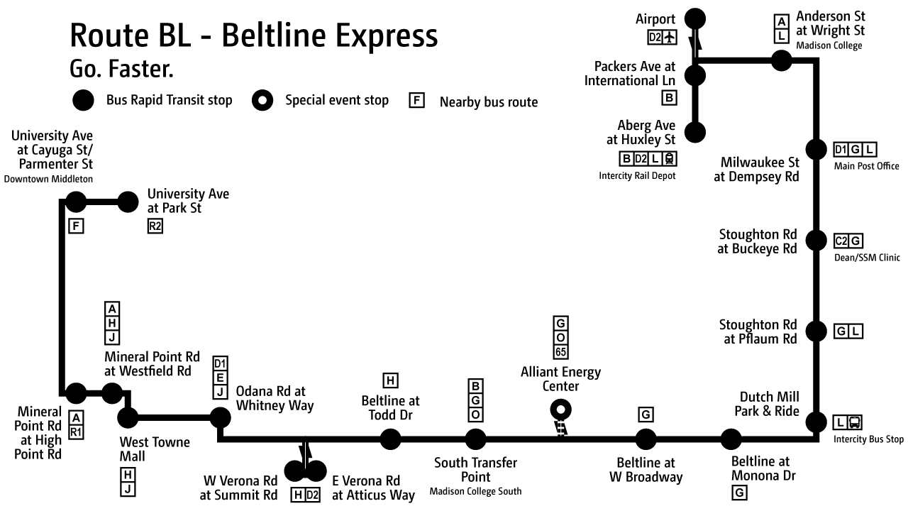
So here is my idea in visual form. With a little downtime over Thanksgiving, I decided to use my hypothetical light rail map from the previous blog post as a template for finally drawing out my ideal Route BL express bus. From east to west, the line begins at the old North Transfer Point, my proposed location for a new intercity rail depot. From there, it heads north to the airport, interfacing with the future BRT Route B at Packers and International along the way. Outbound from the airport, it heads east along Anderson Street to a stop at Madison College, then south along Stoughton Rd (U.S. Highway 51) to a stop on Milwaukee Street.
Though no longer home to the East Transfer Point, Milwaukee Street still serves as a major bus transfer site and destination point for the main post office and Woodman’s discount grocery megamarket. Right away, we’ve connected dense working-class neighborhoods on the North and East Sides with trains, airplanes, key services, and the main community college campus, all in just a couple of stops.
From there, the route takes commuters south along Stoughton Road—a major thoroughfare with a 55 mile per hour speed limit—to the Dutch Mill Park & Ride, with two intermediate stops that serve a large health care facility and minor neighborhood connector routes.
Dutch Mill is one of two boarding points in the city for intercity bus routes, and the only one along a major highway and with overnight parking. It would be a great place for commuters coming from beyond suburbia to park for the day for free and take rapid transit into town—would be, because it lacks an efficient transit connection to the urban core. With the 2023 redesign, at least there is now a regular route that connects it to East Side neighborhoods. Prior to that, there was either nothing at all or a single route that only ran 2-3 buses a day to downtown at rush hour times on weekdays. With Route BL, it becomes a more usable intermodal facility.
At Dutch Mill, the route enters the Beltline westbound, stopping off at two commercial districts: Monona Drive in Monona and South Broadway by South Towne Shopping Center. On most days, next would be the South Transfer Point, from which frequent BRT service would take inbound commuters straight to the UW Campus and Downtown.
There could also be a special event stop serving the Alliant Energy Center just during big events, alleviating parking congestion and maybe even freeing up some of its sea of pavement for better uses. I would put this stop in front of the Exhibition Hall at its northeast corner, rather than way out on Rimrock Road where the present bus routes travel, to increase the level of convenience for bus travelers beyond that of drivers who have to deal with parking.

Beyond the South Transfer Point, Route BL continues west on the Beltline for another four miles with two intermediate stops. It takes advantage of the low-angle exit and entrance ramps onto frontage roads for a stop at Todd Drive, serving a major retail area with nearby apartment complexes. Then, at Verona Road, it loops to the south using the unique configuration of frontages that pass under the divided highway, stopping on each side to serve big box businesses, more apartments, and two standard-frequency bus routes.
At Whitney Way, the bus leaves the Beltline for a time to more directly negotiate the next series of stops. Odana and Whitney is near the former West Transfer Point, but the new system configuration saves a dogleg up to Tokay by creating an interface with three other bus routes at Odana. From there, it’s faster to travel straight across Odana to West Towne Mall than to get back on the Beltline and get off again at Gammon. Route J provides local stops along Odanah, while the BR would traverse it non-stop.
After a stop at the mall, the route takes the mall road up to Mineral Point, then turns west. Mineral Point has two new BRT stops for the Route A, which are closer to each other than the BL’s typical stop interval, but it makes sense to serve them for an easy interface with the A and three other routes.
After High Point, Route BL gets back on the freeway headed north. Between Mineral Point and Middleton, local stops are well served by routes on either side of the Beltline—the F to the west and the R to the east—so there is no need to make the BL stop before University Avenue at downtown Middleton. A final stop at Park Street in Middleton serves the strip mall anchored by Willy Street Co-Op and the surrounding bedroom community.
It’s easy to imagine traveling the route in reverse. The Park Street, Verona Road stops, South Transfer Point, Alliant Energy Center, Dutch Mill Park & Ride, Airport, and Aberg Avenue stops would only need a single platform to serve both directions. The Buckeye and Pflaum stops could make sense as median platforms with crosswalks on either side, similar to the new Route A BRT stops going in along Mineral Point Road. Monona Drive, West Broadway, and Todd Drive would need a stop along the exit ramp or frontage road on opposite sides of the freeway for the opposing directions of travel, unless a lot of money was spent to engineer special platforms directly on the freeway grade. The others stops would likely have a platform on either side of the street for each direction of travel.
Of course, the success of such a route depends a lot on its frequency. Buses would need to come every 10 minutes, 15 tops, during heavy commute times to make it attractive as an alternative to driving. But if it were able to provide even close to the convenience of driving, without the cost and headache of traffic, parking, and gas, such a route could move many commuters to more sustainable ways of traveling on our existing road infrastructure.
