This post is based on a talk I gave at the Nelson Institute Center for Culture, History, and Environment Symposium at UW-Madison on February 11, 2017. Here are the slides from the talk:
Last fall I made a map of the Dakota Access Pipeline’s Missouri River crossing that went viral. One part of the map drew especially vigorous discussion in the comments section of the original post: the area labeled “Sioux Territory Under 1851 Treaty of Ft. Laramie.” Because of that discussion, I changed the label from its initial wording, stripping the word “Unceded” from the beginning. I won’t change it back; for now, this keeps the map on sound legal footing. But here I will explain why I think a strong argument can be made for the original wording, and what it portends for Sioux sovereignty over this contested landscape.
While conducting research for the Black Snake map in mid-October, I connected with a staff member at the Standing Rock Tribe’s Historic Preservation Office who gave me information I could use on the map in exchange for some light GIS assistance. As I was packing up to head back to the Oceti Sakowin camp, this person asked me if I would be willing to digitize and map the boundaries of the Great Sioux Nation.
My response was: The what?
The Great Sioux Nation is a geographic entity that came into existence with the 1851 Treaty of Fort Laramie. Intended to halt Indian attacks on white settlers moving west along the Oregon Trail, the treaty for the first time designated territorial boundaries of the Sioux, Cheyenne, Arapaho, Assiniboine, Mandan, and Arikara peoples. To the Native Americans who roamed the plains as nomads hunting buffalo for subsistence, these boundaries were always in flux, determined by who could best their rivals in counting coup. To the Americans, fixated on expanding their nation-state, defined territory and property boundaries were necessary prerequisites for legal ownership and use of the land. Thus, these boundaries were largely fictitious, but a legal fiction that would bear some fruit in the white man’s court over a century later.

Of course, hostilities between the U.S. and the Sioux in particular did not cease in 1851. In 1868, after a series of skirmishes known as Red Cloud’s War, the U.S. signed another Treaty of Fort Laramie with the Sioux and their allies. This treaty was negotiated shortly after Red Cloud’s warriors massacred 81 American troops under Captain William Fetterman, who the Indians saw as trespassing in the contested Powder River Country (they were protecting white gold prospectors using the Bozeman Trail, whose presence threatened the buffalo herds, the main form of subsistence for the western Sioux). In the wake of the Civil War, the U.S. Army calculated the cost of militarily subduing the proud Sioux as too high, and sued for peace.
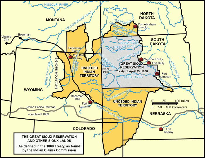
The 1868 treaty contained three sections defining Sioux lands. Article 2 of the treaty designated a “Great Sioux Reservation,” a place where, in theory, Indians who wanted to assimilate could settle into the lifestyle of yeomen farmers. Article 16 recognized Sioux hegemony over the vast Powder River Country, labeling it “unceded Indian territory” and closing American forts and the Bozeman Trail. Article 11 recognized the rights of the Sioux to hunt south of the reservation “so long as the buffalo may range thereon in such numbers as to justify the chase.”
These treaty boundary maps were easily located on the internet, but were too small-scale to digitize accurately. I figured it wouldn’t be too hard to use the treaties themselves to draw in more accurate boundaries, or, failing that, find the sources used by the online maps. As I was leaving the Standing Rock office, I said that I should have something done by the weekend. Boy, was I off. I was staring down a rabbit hole.
The first source I went to, of course, was the treaties themselves. Two problems quickly became apparent: in some cases, the treaty language was very vague and didn’t match up with on-the-ground geography, while in others, the boundaries on the online maps obviously disagreed with what what the text of the treaties said.
Exhibit A: Here are the Sioux boundaries as defined in the 1851 treaty:

The problem lies in this part: “…to a point known as Red Bute (sic), or where the road leaves the river; thence along the range of mountains known as the Black Hills…” Red Butte is just west of modern Casper, Wyoming. The Black Hills—at least as we know them today—are at closest 150 miles to the northeast.

So how does one get from Red Butte to the Black Hills? The boundary on the online maps does not head northeast from Red Butte at all, but rather continues west along the North Platte River, seemingly in violation of this treaty language (otherwise, why would Red Butte be marked as a waypoint on the boundary line at all?).

Exhibit B: Article 11 of the 1868 Treaty states that the Sioux “reserve the right to hunt on any lands north of North Platte, and on the Republican Fork of the Smoky Hill River [now just called the Republican River]” as long as there are buffalo to hunt. But the two rivers are widely separated by a seeming no-mans-land, and what exactly does “on” the Republican River mean, anyway? Again, the maps have an answer, but it’s not a very satisfying one:

(Note that the above map mislabels the southern hunting grounds “unceded Indian territory;” the treaty does not use that term for this area, nor have the courts that interpreted it).
Exhibit C: Article 16 of the 1868 Treaty vaguely defines the “unceded Indian territory” of the Powder River Country as “the country north of the North Platte River and east of the summits of the Big Horn Mountains.” This was well and good for the time the treaty was signed, when everyone knew that the problem was the Bozeman Trail and the string of forts the U.S. had erected to protect it. As a cartographer, I’m fascinated by the problem of symbolizing vague and poorly defined boundaries; there are plenty of ways to show land claims without drawing a hard line around them. But that is exactly not what the online treaty maps do. There are very definite lines drawn around this area; some segments obviously follow rivers, while in other spots the underlying geography is not obvious, but the border clearly follows something. Then there’s that big finger-shaped hole in the territory that juts down from the north like a peninsula; what’s that about?

So I had to figure out where these boundaries were coming from. That took me to the book Black Hills, White Justice by Edward Lazarus, which appears to be the original source of the online maps. Lazarus is the son of one of the attorneys who prosecuted a pair of Sioux cases against the U.S. to gain compensation for usurped treaty lands, including the sacred Black Hills. The Black Hills case went all the way to the U.S. Supreme Court, which sided with the Sioux in 1980 and awarded them over $100 million for the unilateral “taking” of the Hills by Congress in 1877 (an episode of which a lower court famously declared, “A more ripe and rank case of dishonorable dealings will never, in all probability, be found in our history”). The other case called for remuneration for land rights ostensibly relinquished under the 1868 treaty, and eventually won the Sioux an additional $40 million.
By the time the Sioux won these cases, they had been in court for almost six decades. The intervening years saw a revolution in Native American attitudes toward their own sovereignty. Fearing that monetary compensation would absolve the U.S. government of any responsibility to give back the land they had stolen, the Sioux have refused to touch the money. Today it sits collecting interest in a BIA-administered trust now worth well over $1 billion.

Lazarus’s book is a splendid bit of storytelling, and vividly recounts the whole convoluted history of U.S.-Sioux legal relations, from the fights that led to the 1851 treaty, to the theft of the Black Hills, to the high court’s ruling on the Hills and the Sioux response. But Lazarus is a lawyer, not a cartographer, and his primary focus is on the shifting jurisprudence around Indian legal rights and treaty claims, not on the geographic boundaries of those claims. Nonetheless, his book at least pointed me in the right direction: toward the Indian Claims Commission, a special court created by Congress in the New Deal era to adjudicate outstanding Indian treaty claims.
In the act that created the ICC, Congress gave the Commission the power not only to interpret Indian treaties, but to literally redraw disputed treaty boundaries and then make decisions as if they were the original boundaries. And, it turns out, this is just what the ICC did in regards to the 1851 and 1868 Sioux treaties.
In 1965, the Commission took up the issue of the 1851 Sioux territory’s western boundary (the part that went from Red Butte “along the range of mountains known as the Black Hills”). In its decision (15 ICC 577), the Commission thoroughly reviewed the background and tenor of the negotiations that led the treaty, including the boundary lines drawn on the (highly inaccurate) maps made at the time, and concluded “that the proper location of the Sioux western boundary… follows the drainage divide between the rivers flowing east into the Missouri and those flowing north into the Missouri.” This seemingly logical conclusion produced this territory:

But it didn’t make the lawyers for the Sioux happy. The problem, they pointed out, is that the new boundary left a large “neutral zone” between the Sioux and their western neighbors and bitter rivals, the Crow. The eastern Crow boundary specified in the treaty follows the Powder River rather than the “Black Hills” used by the Sioux boundary. The attorneys argued that the land in between rightfully belonged to the Sioux under the terms of the treaty—and should be compensated for. In 1969 (21 ICC 371), the Commission agreed, nullifying its previous boundary and redrawing the 1851 territory thus:

To determine the exact line of the western boundary, the ICC relied on a set of maps of Indian land cessions drawn by Charles C. Royce for an 1896 report to the Smithsonian Institution. The 1851 Sioux boundary eventually settled on by the Commission follows the line between area 517—land ceded by the Crow in a separate treaty—and area 597, or what Royce identified as Sioux territory supposedly ceded by the illegitimate 1876 “agreement” cited by Congress to annex the Black Hills.

Royce produced maps like this for every state (more than one for some states), and luckily they have all been scanned at high resolution and are now hosted online by the Library of Congress. They were the last piece of my puzzle. They are based on the Public Lands Survey and highly accurate for the time. With a little bit of georeferencing work in GIS software, they gave me something to trace where no rivers, graticule lines, or modern political boundaries otherwise demarcated the ICC’s treaty boundary line.
The geography of the 1868 treaty is a bit more complex than the 1851 territory, and remains contested. The latter treaty is especially important to modern Sioux sovereignty because it is regarded as the last legitimate treaty between the U.S. and the Sioux. The sell-or-starve “agreement” giving up the Black Hills in 1876 was signed by just a handful of war-broken chiefs, violating a key provision of the 1868 treaty stipulating that it could only be superseded by signature of 3/4 of the adult male Sioux population. This “rank case of dishonorable dealings” was cited by the Supreme Court as a key factor in its 1980 decision.
To review, the 1868 treaty declared three types of Sioux lands: the Great Sioux Reservation, on which the Sioux could permanently settle (not that they wanted to); hunting grounds available for Sioux use as long as they contained free-ranging buffalo (which were decimated within a few years of the treaty’s signing); and unceded Indian territory, where the unconquered western Sioux could roam and hunt in the lifestyle to which they were accustomed without harassment by U.S. soldiers or fortune-seekers. The treaty language is quite clear on the boundaries of the reservation, which basically covers the western half of what is now South Dakota along with slivers of North Dakota and Nebraska. The other two treaty areas are less clear.
In 1970, the ICC rendered a pair of decisions drawing boundaries around the southern hunting grounds and western unceded territory (24 ICC 98 and 23 ICC 358, respectively). These decisions were clearly somewhat arbitrary, drawing solid lines where perhaps there should not have been based on the post-1868 land cessions on Royce’s maps. Importantly, and against the arguments of the Sioux counsel, the Commission arbitrarily decided that the eastern boundary of the unceded territory—”the country north of the North Platte river and east of the summits of the Big Horn mountains”—aligned with the western boundary of the reservation on the 104th meridian (104º west longitude). This decision excluded the 1851 Sioux territory to the north of the reservation, which then fell under Article 2 of the 1868 treaty, relinquishing all Sioux claims to territory outside of the lands described by the treaty.

But this isn’t the end of the story. In a 1978 decision(42 ICC 214), the Commission again modified its earlier findings, declaring that, based on the tenor of treaty negotiations, “the Indians cannot have regarded the 1868 treaty as a treaty of cession.” This would tend to suggest that the 1851 Sioux territory to the north of the reservation should be included in the unceded Indian territory that the Sioux did not believe they were giving up. Thus:

So the Great Sioux Nation, then, could be constituted by the Great Sioux Reservation and unceded Indian territory to the west and north of the reservation, as designated by the 1868 treaty and interpreted by the ICC, and possibly 1851 territory within the hunting areas to the south of the reservation. Why is this important now? It is the ambiguously designated northern segment of 1851 Sioux territory through which the Dakota Access Pipeline—the Black Snake—passes.

In an article published last month by the Indian Country Media Network, a University of New Mexico Ph.D. student, Nick Estes, and a University of Oregon history professor, Jeffrey Ostler, argue based on the 1978 ICC decision that the pipeline passes through territory never legally ceded by the Sioux. Thus, they say, it is especially imperative for the government to respect the tribe’s right to consult on and even veto dangerous infrastructure projects in the area (I would add, particularly given that the original intent of the “unceded Indian territory” was to check the growth of American infrastructure). Their exact claim—that the ICC declared “the northern boundary of the unceded Article 16 lands was the Heart River”—I can’t find support for in the wording of any ICC decision. But I agree with the logic of their argument, and I certainly think a court should definitively nullify the arbitrary and ahistorical 104º eastern limit of the unceded territory.
Would a modern court recognize that the Sioux maintain treaty rights in the 1868 unceded territory, including this northern zone? And if so, what would the nature of those rights be? In the 1990s, the Ojibwe tribes of northern Wisconsin won (back) their treaty rights to hunt and fish off reservation in ceded territory. But the idea that Native American treaty rights could include veto power over infrastructure and industrial development has not, to my knowledge, ever been tested in court. Given that the Standing Rock Sioux Tribe is fast running out of other legal avenues to block the Black Snake, perhaps it’s time to test it.
Note: My maps of Sioux treaty boundaries use state boundary and terrain data from the US Geological Survey and satellite imagery data from Digital Globe via ESRI. All maps in this post authored by me are licensed CC-BY.
